
As a Viking Age scholar there is a particular kind of island I particularly enjoy visiting: not the islands that were merely raided, and not the islands that were thoroughly colonised and renamed (actually I like these islands too!), but the islands that sat between — where Norse-speakers arrived, settled, intermarried, prayed, fought, and were within a generation or two speaking Gaelic again, leaving behind a landscape that is neither fully Norse nor fully Gaelic but something else: a palimpsest, a contact zone. Bute, low and green in the Firth of Clyde, guarding the entrance to Loch Fyne, the entrance to the River Clyde, and the sea-road to Ireland, is one of the clearest examples of this phenomenon in Scotland. As Barbara Crawford puts it in her authoritative survey of the Norse west, Bute — together with its neighbours Arran and the Cumbraes — was “strategically-located” in “a maritime world of mixed ethnic identity,” a place where “Norse and Scottish culture met and where national political ambitions clashed” (Crawford, 2012, p.46). Bute’s place-names, its sculpture, its documentary scraps, and its eventual absorption into the Stewart lordship all tell the story of a frontier that mattered far more than its modest size suggests.
This posting traces that story in four movements: what the island’s names tell us about who lived there and how; what archaeologists have recovered; how Bute fits into the wider, hybrid world of the Gall-Gaidheil, the “foreigner-Gaels” of the Irish Sea; and how, when Norway made its last two serious bids for the island in the thirteenth century, the family who held Rothesay Castle rode that crisis all the way to the Scottish throne — and, remarkably, still owns most of Bute today.
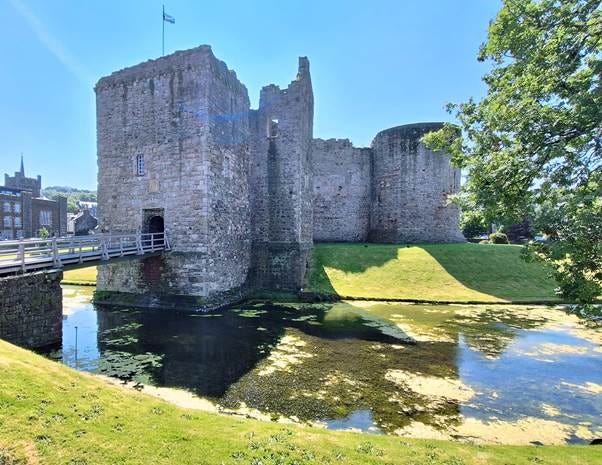
Rothesay Castle
Movement 1 - what do the place-names tell us?
The island’s own name – Bute - is a puzzle. Watson and Mac an Tàilleir favour an Old Irish root, bót, meaning “fire,” perhaps recalling beacon or signal fires visible across the Clyde. However, I find this unconvincing. To me it seems like one of the old island names like Skye and Mull, both of which were recorded by Ptolemy in the 2nd century. Although Bute does not occur in his Geographica, the Ravenna Cosmography (a 7th-century Latin geographical compilation drawing on older, likely Roman-era, source material) records an island called Botis, generally identified by place-name scholars as Bute. This has been analysed by Rivet and Smith, in their The Place-Names of Roman Britain (1979). They suggest that it is root-identical with the Brittonic/Celtic “dwelling” word (the same root that gives Welsh bod, “dwelling, abode,” and is familiar from place-names like Cornish Bodmin or Welsh Bodedern). On this reading, Bute’s name would mean something like “dwelling(s) island” — either describing the whole island as a settled territory or naming it after one particularly prominent settlement on it. Whatever its origins, the Norse who sailed past evidently borrowed the name and called the island Bót. For example, the name turns up in Grettir’s Saga, which relates a story of one group of Norsemen getting into a fight with some others ‘who lay up in winter in the Barra Isles’ and the sea battle took place in narrow straits off Bute.
Two Vikings-Vigbiod and Vestmar were raiding in the Hebrides and plundering in Scotland’s firths. Thrond and Onund went to oppose them and learned that they had sailed in to the island which is called Bute. They took five ships and Onund put them between two cliffs; there was a great channel there which was deep, and ships could sail one way only, and not more than five at a time. Onund made the five ships go forward into the strait in such a manner that they could immediately let themselves drift, with hanging oars, when they wished, because there was much sea-room behind them. There was also a certain island on one side, under it he made one ship lie and they carried many stones to the edge of the cliff, where they could not be seen from the ships. (Grettir’s Saga chap 4).
The chief town, by contrast, is unambiguously Norse. Rothesay derives, on Gilbert Márkus’s reading, from a personal name — Ruðri, later Gaelicised as Ruairidh — attached to Old Norse ey, “island”: Rothri’s isle. Márkus suggests the name was probably coined for the whole island before it narrowed, by the thirteenth century, to describe the castle and the town beneath it, which in Gaelic retained the older and more transparent name Baile Bhòid, “the town of Bute” (Márkus, 2012). It is one of the more striking coincidences in this whole story that Hákonar saga names a ship-captain called Ruðri as the man who, in 1263, pressed a hereditary claim to Bute on Norway’s behalf (see below). Whether that saga Rudri has any connection to the personal name embedded in “Rothesay” two centuries earlier is impossible to prove, but it is a genuinely tantalising echo.
Beyond Rothesay, the map yields a modest but telling scatter of Norse coinages: Ascog, from askr (”ash tree”) and vík (”bay”); Shalunt, from sjár (”sea”) and lundr (”wood” or “grove”); Roseland, from hrossa (”horses”) and land; Birgidale and Dumburgadale, both carrying Old Norse dalr, “valley”; and Corval, containing fjall, “hill.” Even the Gaelic name for the fortified promontory at the island’s south-west tip, Dunagoil — dùn nan gall, “fort of the foreigners” — is itself a memory of the Norse presence, preserved not in a Norse word but in the Gaelic label the newcomers were given.
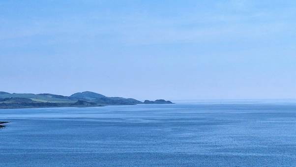
Dunagoil
What is striking, and what has occupied place-name scholars for half a century, is less what is present than what is absent. In the classic Norse-settled zones — the Northern Isles, the Hebrides, the Isle of Man — the landscape is dense with habitative elements: bólstaðr (”farmstead”), setr (”shieling” or dwelling), staðir (”homestead”). These are the names of places that Norse-speaking communities founded, subdivided, and lived in generation after generation. On Bute, as on neighbouring Arran and Kintyre, such names are entirely absent. What survives instead is almost exclusively topographical — dalr, vík, fjall — the vocabulary of people describing a landscape rather than founding a lineage of farms within it.
W. F. H. Nicolaisen, writing in the 1970s, took this absence at face value: for him it meant that Norse speakers on the Argyll coast were essentially passing through, leaving what he memorably called “onomastic graffiti” rather than settling in numbers (Nicolaisen, 1976). Gilbert Márkus, building on the work of myself and Arne Kruse on the wider Gall-Gaidheil zone, has offered a more interesting reading. Rather than reading the absence of habitative names as evidence of thin, transient contact, Márkus argues it is evidence of settlement that was both real and remarkably short-lived in linguistic terms — Norse-speaking families did arrive and did settle Bute in the primary phase of colonisation (hence the topographical layer), but they, or their children, had shifted to speaking Gaelic so quickly that by the time farms were being subdivided and new settlements named — the stage at which habitative names normally proliferate — the naming was already being done in Gaelic (Márkus, 2012; Jennings and Kruse, 2009). Ascog is the textbook case: a primary Norse-named farm (askr-vík) later split into Kerrycroy, Kerrycrusach, and Over, Nether and Mid Ascog — Gaelic and Scots names layered onto a Norse core, exactly the pattern the theory predicts. In addition, Crawford makes the case that the name Langal at the south end of the island near Kingarth — a name she identifies as cognate with Langal/Langwell names found across northern Scotland, deriving from Old Norse lang-völlr, “long field or level plain,” a description that, she notes, “appears to describe the area very well” (Crawford, 2012, p.36). Crucially, Langal was not a passing description: it was originally a substantial estate of twelve merks, later divided into two farms that carry Gaelic suffixes today. Crawford’s argument is that völlr names of this kind were doing the job that bólstaðr, setr and staðir normally do elsewhere — functioning as genuine farm-names.
The comparison with the Hebrides and Man sharpens the point. Where those island groups retained Norse speech and dense Norse toponymy for centuries, Bute — sitting in the inner, more sheltered waters of the Firth of Clyde, closer to the political gravity of Gaelic Argyll and Strathclyde — shows a thinner Norse layer that was rapidly overwritten. Even so, Crawford is emphatic that what survives on Bute is not negligible: “there is a still-surviving stratum of Old Norse topographical names in Bute which can be used to provide evidence of the establishment of Norse speakers and land-owners” (Crawford, 2012, p.36).
Movement 2 – what does the archaeology tell us?
Place-names describe a linguistic event. Archaeology, when it survives, can describe a material one — and on Bute it does, unevenly but suggestively, add to the picture that Norse-speaking people were not just passing offshore but living, dying, and worshipping on the island.
As yet, unlike Arran, no Viking grave has been securely identified. However, the Drumachloy sword-hilt, recovered near Ettrick Bay and now in Bute Museum, might have come from a grave. It has a Norwegian-type hilt, damaged and corroded, its pommel lost, with 1977 X-rays revealing a probable chequerboard inlay of copper or silver alloy. Crawford treats this as “probably from a Norse grave,” noting that “it is unusual for a sword hilt of that quality to be found in a context other than in association with a pagan grave,” and cites F.T. Wainwright’s observation that “warriors do not leave their swords casually in barns or byres, nor do they throw them on middens” (Crawford, 2012, p.36, n.5, citing Wainwright, 1955, p.152). No grave has actually been excavated around the find, so this remains an inference rather than a confirmed burial — but it is the strongest inferential case on the island.
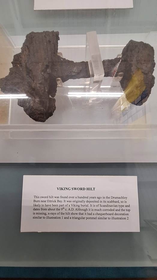
Drumachloy Sword Hilt
At the impressive site of Little Dunagoil, on the same promontory as the early church site of St Blane’s, whose Gaelic name records “the fort of the foreigners,” excavations in the 1960s uncovered two large rectangular buildings interpreted at the time as Norse longhouses, together with a probable Norse comb fragment and a weight of Scandinavian character (Marshall, 1964). However, a later settlement survey has urged caution: the “longhouses” are structurally ambiguous and their Norse attribution not securely established (Isle of Bute Settlement Survey, 1999). Nonetheless, the comb and weight do suggest the site was inhabited in the Norse period. More recently, at Cnoc an Rath, in the Borgadale valley, archaeologist Paul Duffy has obtained radiocarbon dates from a buried surface falling in the late seventh to late ninth centuries — squarely within the period of Viking activity in Argyll — and has proposed, more speculatively, that the mound may be a Norse assembly or thing site, conceivably even connected to the historically attested Gall-Gaidheil leader Ketill Flatnose (Duffy, in Ancient Origins, 2015). This remains a hypothesis rather than a settled finding: the radiocarbon evidence is consistent with a Norse date, but it does not by itself demonstrate an assembly function.
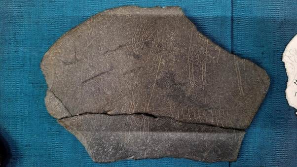
The Hostage Stone
Finally, there is the small island of Inchmarnock, off Bute’s western shore. It was an early monastic site, and has produced what is probably the most evocative single artefact in the whole story: the so-called Hostage Stone, an incised slate apparently depicting a bound figure, apparently a monk, being led towards a boat by a figure in chainmail — widely, though not universally, read as a depiction of a Viking raid on the monastery (Lowe, 2008). I am unable to see the chain that supposedly binds the monk to the warrior, so perhaps I need the eye of faith! Personally, I prefer, the other important stone from Inchmarnock, a rune-inscribed cross, which commemorates someone called Guðleif or Guðleik. Who was he and why was he commemorated at this monastic site? Was he a native of Bute, or might he have been a member of King Hakon’s invasion fleet?
Archaeologically, Bute’s Norse remains are modest: a probable but unproven sword-grave, an ambiguous longhouse site with one certainly Viking curated object, the Hostage Stone, and a rune-stone. Crawford’s own verdict is the fair one: “this evidence may be thin and scattered and unimpressive on its own but when all is added up — the archaeology, the place-names, the runestone and the saga reference — it suggests that Bute was very much part of the Viking world, even if that world became rapidly Gaelicised in the tenth century” (Crawford, 2012, p.37).
Movement 3 - Bute among the Gall-Gaidheil
The archaeology and the place-names describe a local, material reality. But Bute’s significance in the Viking Age is best understood at a wider, regional scale: as part of the world of the Gall-Gaidheil, literally “foreigner-Gaels,” the hybrid Norse-Gaelic population and political culture that came to dominate western Scotland and the# Clyde estuary from the ninth century onward. The Gall-Gaidheil were the product of exactly the process the place-names imply — Scandinavian settlers intermarrying with, and assimilating the language and Christianity of, the Gaelic-speaking populations of the Inner Hebrides, and the western coasts. Their name survives directly in Galloway (Gall-Ghaidhealaibh, “among the Gall-Gaidheil”).
Bute’s place within this world is not a matter of inference alone; it is directly attested. The early Irish Martyrology of Tallaght, compiled around AD 900, records St Blane, bishop of Kingarth on Bute, as belonging “in Gall-Ghàidheil” — an explicit ninth- or tenth-century statement locating Bute within Gall-Gaidheil territory (Márkus, 2012). The Félire Óengusso makes a similar association. This is a rare thing in the Viking Age documentary record of the west of Scotland: a specific, named, dateable text placing a specific island inside the political-cultural geography of the Gall-Gaidheil, rather than leaving historians to reconstruct that geography from silence and topography alone. Bute, given its fertility and strategic geographical position, might in fact have been the heartland of Gall-Gaidheil territory.
Bute’s ecclesiastical history in the twelfth century reinforces this sense of the island’s regional importance long after any “Viking Age” proper had ended. When the archdiocese of Nidaros (Trondheim) was created in 1152–3, the diocese of the Hebrides — Suðreyjar, or Sodor — was placed under it, formalising a Norwegian ecclesiastical claim over the Hebridean church (Crawford, 2012, pp.41–42, citing Beuermann, 2002). Within that diocese, distinct regions appear to have clustered around their own principal churches, to which a bishop based at Peel in Man would pay occasional visitations: Snizort in Skye and Rodel in Harris for the northern Hebrides, Iona as the diocese’s most important spiritual centre overall, and — in the Clyde estuary — Kingarth in Bute (Crawford, 2012, p.41, citing Woolf, 2003, pp.180). Bute, in other words, was still functioning as one of only four recognised regional ecclesiastical centres of the entire Hebridean diocese in the mid-twelfth century, three centuries after the first Norse settlers are likely to have arrived.
Political control of the hybrid world of which Bute was part, kept changing hands. In the twelfth century the Kings of Man, were in competition with Somerled. After the Battle of Epiphany in 1156, the Kingdom of the Isles was split between Somerled and King Godred of Man — an event the Manx chronicler blamed for the kingdom’s ruin — with Somerled and his sons controlling the southern Hebrides south of Ardnamurchan, “possibly including Arran and Bute” (Crawford, 2012, p.42, citing McDonald, 1997, p.56). Crawford is honest that the sources do not settle Bute’s exact allegiance in this period. However, what is not in doubt is that the island’s strategic value meant the both the Kings of Man and Somerled and his heirs would have wanted to possess it. At the same time, we must not forget though that both competing forces owed allegiance to the Kings of Norway, who since the 1090s had been overlords of the Hebrides. Bute was about to fall out of the Norwegian king’s orbit and into the hands of the Stewarts.
Movement 4 – Stewart encroachment and Norwegian campaigns
The Stewart claim to Bute did not arrive out of nowhere in 1200; it can be dated with unusual precision to a specific documentary act. Crawford points to Alan fitz Walter’s grant, made before 1204, of Kingarth with its lands and chapels to Paisley Abbey — the Stewart family’s own monastic foundation on the Clyde — as clear evidence of “the Stewart family’s attempted extension of power over the Clyde from Renfrewshire to the island of Bute” (Crawford, 2012, p.44). The grant, tellingly, “seems never to have been implemented” (Crawford, 2012, p.44, n.8) — a sign that Stewart ambition on Bute in 1200 was running ahead of Stewart control on the ground. Alexander II mounted a royal campaign in the area in 1222 which was “possibly aimed at royal control of Arran and Bute” (McDonald, 1997, p.84, cited in Crawford, 2012, p.44), and by 1230 Scottish . Stewart position had solidified enough that a Scottish garrison held Rothesay Castle (Crawford, 2012, p.44) — the target that year of the Norwegian-backed assault traditionally associated with Uspak (Óspak-Hákon), recorded in Hákonar saga as the earliest known account of an assault on a Scottish castle, in which the Norse are said to have hewn through the castle’s soft stone wall with axes before withdrawing, Uspak dying of his wounds soon after.
There was a much larger Norwegian assault in 1263.While King Haakon’s fleet lay at Gigha — the saga’s Guðey — he detached ships to Bute “to meet those who had been sent thither.” Among the Norwegians was a ship-captain named Ruðri (see above), who believed he had a hereditary claim to the island; his name suggests, that he may have belonged to the MacSorleys, the descendants of Somerled (Crawford, 2012, pp.44–45, n.10). Having failed to win the island back from the Scots by his own means, Ruðri and his two brothers swore allegiance to King Hákon. What followed was a skirmish at “the castle” — presumably Rothesay — in which Rudri killed nine men, after which the island passed under Norwegian control; the Norwegian court poet Sturla Þórðarson later commemorated the reconquest of “broad Bute” from its Scottish holders in verse (Crawford, 2012, p.45).
Bute then became briefly a Norwegian forward base, from which Ruðri’s men harried the nearby Scottish coast, prompting the Scots to open negotiations, met by a Norwegian embassy sent to King Alexander at Ayr. Those talks collapsed over one specific, named sticking point: Hákon’s claim to all the isles, which Alexander refused to concede where it touched the Clyde islands by name — recorded in the saga as Bot ok Herrey ok Kumreyjar, “Bute and Arran and the Cumbraes.” Neither king would yield these three islands, and it was this deadlock, probably more than any other single issue, that broke the negotiations down (Crawford, 2012, p.45). Hákon then sailed his fleet directly into the Clyde and anchored under the Cumbraes in open defiance of Alexander’s authority. While anchored there, he detached sixty ships under King Magnus of Man and the MacSorley brothers Dougal and Alan to raid up Loch Long and across the Tarbert portage into Loch Lomond, “and wrought there great damage” — a raid that inflicted real destruction but did nothing to resolve the deteriorating position of the main fleet in the Clyde, which autumn storms had already begun to batter before the skirmishing at Largs on 2 October (Crawford, 2012, p.45). After the inconclusive encounter there, Hákon’s fleet withdrew north, reached Orkney by 29 October, and settled in to overwinter — a decision cut short by the king’s death that December, which effectively ended Norwegian political ambitions in the west.
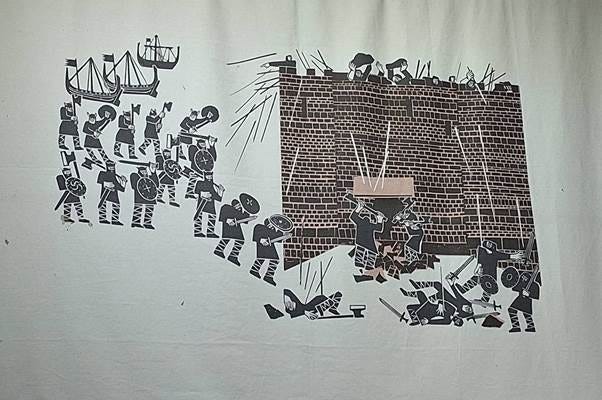
Norse attacking Rothesay Castle
The Treaty of Perth, concluded on 2 July 1266 between Hákon’s peaceable successor Magnus “the Law-mender” and the Scottish crown, formalised what the Largs campaign had already made practically inevitable. Framed almost as a sale — the Hebrides and Man ceded to Scotland in exchange for four thousand merks and a perpetual annual payment of one hundred merks — the treaty also protected Hákon’s former supporters from reprisal, allowing them to stay or leave “with their goods, lawfully, freely, and in full peace” (Donaldson, 1970, p.35, cited in Crawford, 2012, p.46). Rothesay Castle’s unique circular curtain wall, still stands as a mute witness of this warlike clash between the Kings of Norway and Scotland.
The Stewarts: from frontier keepers to kings, to landlords still
It would be easy, telling this story, to treat 1266 as the natural endpoint in Bute’s interesting history — Norway defeated, the frontier closed, the Gall-Gaidheil chapter of Bute’s history over. Indeed, it was the endpoint for the Norse era of Bute’s history. However, even someone like me with a particular interest in the Viking period, the later History of Bute is also fascinating. The Stewart (later Stuart) era was just beginning, and in a sense, it continues to this day.
The Stewarts descended from Walter fitz Alan, a Breton-Norman adventurer who arrived in Scotland under David I and was made hereditary Steward — dapifer — of the Scottish crown around 1150; the office title eventually hardened into the family surname. His son Alan, second High Steward, acquired Bute around 1200, as we have said, and either he or his son Walter, the third High Steward, built the circular stone castle at Rothesay that would twice withstand — and twice briefly fall to — Norwegian assault. The family’s fortunes rose sharply during the Wars of Independence: Walter, sixth High Steward, married Marjorie Bruce, daughter of Robert the Bruce, an alliance commemorated in the Bute Mazer, a maple communal drinking bowl made around 1314–1327, its silver-gilt central boss showing a recumbent lion representing Robert I encircled by the shields of six of his chief supporters, with the Stewart arms set between the lion’s paws.
When David II died childless in 1371, the crown passed to Marjorie and Walter’s son, who became King Robert II, the first monarch of the House of Stewart. Rothesay Castle, the frontier fortress that had absorbed two Norwegian sieges, became a royal residence; Robert III would die there in 1406. Robert III gave his heir the title Duke of Rothesay — the first dukedom created in Scotland — and that title, remarkably, is still borne by the heir to the British throne today, a six-hundred-year-old survival that ties the modern monarchy directly back to the Norse wars fought for possession of this one small Clyde island.
The family that still owns much of Bute today descends not from the royal line itself but from a collateral branch: Sir John Stewart, known as “the Black Stewart,” an illegitimate son of Robert II, who by a charter of 1400 was made hereditary Sheriff of Bute, with his descendants later confirmed as hereditary keepers of Rothesay Castle. Ennobled steadily over the following three centuries — Nova Scotia baronets from 1627, Earls of Bute from 1703 — the family reached its greatest prominence with John Stuart, third Earl of Bute, tutor and confidant of George III, who served as Prime Minister of Great Britain from 1762 to 1763. His son became the first Marquess of Bute in 1796, and through a marriage to the Crichton heiress of the Earls of Dumfries the family took the compound surname Crichton-Stuart still in use today. The second Marquess built his fortune on the Cardiff docks and the coal seams of Glamorgan; the third Marquess, one of the wealthiest men in Victorian Britain, used part of that fortune to rebuild Mount Stuart House on Bute as a lavish Gothic Revival palace — reputedly the first house in Scotland fitted with purpose-built electric lighting and an indoor heated pool — and to restore both Rothesay Castle and Cardiff Castle.
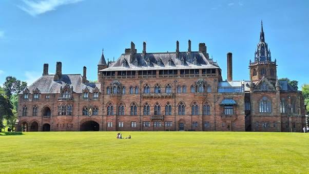
Mount Stuart
That wealth, channelled through the modern Mount Stuart Trust, a charitable trust established in 1985, is the mechanism by which the family’s landholding on Bute persists into the present. By the Trust’s own account it remains custodian of some eighty-seven per cent of the Isle of Bute, of which it directly manages around sixteen per cent, the remainder held through long-term tenancies and partnerships — including, since 2020, new agricultural leases bringing six farming families to the island. The Gazetteer for Scotland records the wider Bute Estate as extending to roughly 10,900 hectares, comprising, per Scottish Land & Estates, some thirty-six farms, around a hundred residential properties and substantial woodland. Mount Stuart House itself, opened to visitors since the 1990s, remains the island’s principal tourist draw, and the current head of the family, John Bryson Crichton-Stuart, eighth Marquess of Bute (succeeded 2021), holds — in an unbroken line running back to the Black Stewart’s 1400 charter — the hereditary keepership of the castle that once withstood the Norwegian fleets, though the castle itself has been in state care, now under Historic Environment Scotland, since 1961.
Coda
There is something fitting, if largely accidental, about the fact that the family now most associated with Bute is itself descended from the very Stewarts who were granted the island precisely because it was a contested frontier. The family whose ancestors held Rothesay castle against Haakon’s fleet. Bute is a small island. But as a case study in what happens when Norse and Gaelic worlds meet, fuse, and are fought over, it is very hard to improve upon.
References
Anderson, A.O. (ed.), 1922. Early Sources of Scottish History, 500–1286 AD. 2 vols. (reprinted Stamford, 1990). [Source for the Grettir’s Saga extract and other early source translations.]
Crawford, B.E., 2012. The Norse in the west, with particular reference to Bute. In: A. Ritchie (ed.) Historic Bute: Land and People. Edinburgh: Scottish Society for Northern Studies, pp.33–48.
Donaldson, G. (ed.), 1970. Scottish Historical Documents.
Duffy, P., 2015. Cited in: Ancient Origins, Archaeologists Discover Remains of Viking Parliament of Medieval Norse King in Scotland.
Hákonar saga Hákonarsonar, trans. Sir G.W. Dasent, 1894. Icelandic Sagas vol. IV, Chronicles and Memorials of Great Britain and Ireland during the Middle Ages. Rolls Series, London.
Isle of Bute Settlement Survey, 1999. Little Dunagoil survey report.
Jennings, A. and Kruse, A., 2009. From Dál Riata to the Gall-Ghàidheil. In: Viking Settlements and Viking Society: Papers from the Proceedings of the Sixteenth Viking Congress, University of Iceland Press.
Lowe, C., 2008. Inchmarnock: An Early Historic Island Monastery and its Archaeological Landscape. Edinburgh: Society of Antiquaries of Scotland.
Mac an Tàilleir, I., 2003. Ainmean-àite/Placenames. Edinburgh: Pàrlamaid na h-Alba/Scottish Parliament.
Marshall, D.N., 1964. Excavations at Little Dunagoil. Transactions of the Buteshire Natural History Society, 16, pp.30–70.
Márkus, G., 2012. The Place-Names of Bute. Donington: Shaun Tyas.
McDonald, R.A., 1997. The Kingdom of the Isles: Scotland’s Western Seaboard, c.1100–c.1336. East Linton: Tuckwell Press.
Mount Stuart Trust, n.d. About the Trust. [online] Available at: mountstuart.com [Accessed July 2026].
Nicolaisen, W.F.H., 1976. Scottish Place-Names: Their Study and Significance. London: Batsford.
Rivet, A.L.F. and Smith, C., 1979. The Place-Names of Roman Britain. London: Batsford.
Wainwright, F.T., 1955. Cited in Crawford, B.E., 2012, Historic Bute: Land and People, p.36, n.5. [Original publication details not independently verified — worth chasing down before publication.]
Watson, W.J., 1926. History of the Celtic Place-Names of Scotland. Edinburgh: William Blackwood and Sons.
Woolf, A., 2003. The Diocese of Sudreyar. In: S. Imsen (ed.) Ecclesia Nidrosiensis 1153–1537. Trondheim: Senter for Middelalder Studier, NTNU, pp.171–182.
Fascinating, and beautifully written. Just one typo: "it’s origins".
I enjoyed this, thank you. But what is the rationale for dating the Martyrology of Tallaght to c. 900? I think that most scholars, following Pádraig Ó Riain, would now put it in the first third of the ninth century, with an older core that was compiled on Iona 715 x 740. This core would seem to have included Bláán's entry, which in turn surely points to 'i nGallgaedelaib' as a later gloss - but how much later is open to question. (Likewise the mention of Gallgaidelaib in the Félire Oengusso is from the twelfth-century scholia, not the ninth-century text.)