The Kame of Isbister: A First Millennium Stronghold on the Edge of the World

Introduction
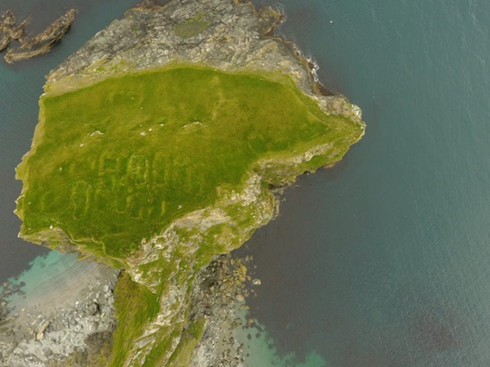
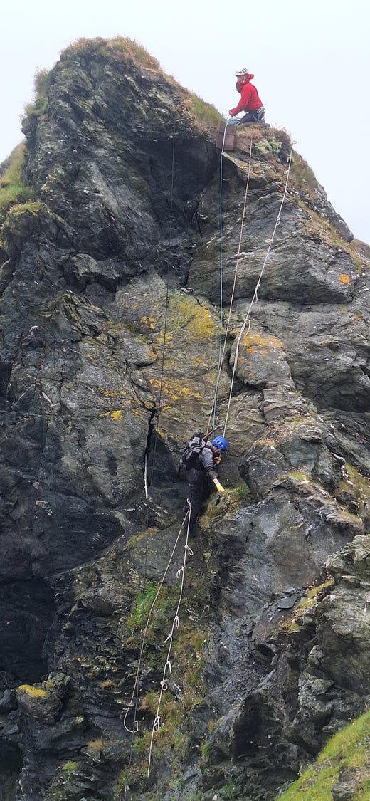
There are some archaeological sites that lodge in the imagination and refuse to leave. For me, the Kame of Isbister has been one of those sites for years. A 38-metre high rocky headland of mica slate jutting into Yell Sound from the remote parish of Northmavine in northern Shetland, it is becoming, through coastal erosion, an increasingly isolated sea-stack. Access is now only possible by a hairy roped ascent with pitons, or a dodgy small boat experience. Swimming is also an option! The nearest settlement is a kilometre’s walk over rough grazing land. And yet, on its summit and sloping flanks, there are the remains of some 23 rectangular stone-and-turf structures, a possible rampart, and deposits that have produced a suite of radiocarbon dates placing human activity here from the late 9th through to the early 12th century. The ambition to understand this site has been with me for years, and the 2024 season—carried out in collaboration with Professor Gordon Noble of the University of Aberdeen, who was hoping to add the Kame to his list of Pictish sites explored in his Northern Picts project —finally made it possible to put trowel to turf.
What follows is a summary of that work, its results, and what we think it might mean—while being honest about how much remains to be resolved.
The Site and Its Setting
The Kame of Isbister (HU 3816 9150; Scheduled Monument SM3880) sits in the parish of Northmavine, North Roe, some 40 miles north of Lerwick. It is a site of genuinely striking presence. From the sea, despite the structures standing only around half a metre above the turf, they are clearly visible from the coast of Yell, 5.5km across the Sound. That seaward perspective matters enormously for how we interpret the place. Standing on the Kame, one does not feel hidden; one feels dominant. The headland commands the view in every direction.
The enclosed area measures approximately 95 x 55 m. On the summit are around 15 rectangular structures, with three more on the south-eastern edge and one or two near the bottom of the slope adjacent to an earthen bank or possible rampart. The larger summit buildings measure roughly 7 x 3 m internally; the isolated building lower down is approximately 8 x 4 m internally. On its western side the Kame is connected to the Shetland mainland by a knife-edge ridge, now impassable. A deep sea-cave penetrates the northern face. On the eastern side, bare rock faces directly onto Yell Sound.
The structures are small and rectangular, similar but generally smaller than the Viking houses on Brough of Deerness, Orkney, though one Deerness structure, Structure 23, is of similar dimensions and construction. However, the structures also resemble those of Brei Holm, Shetland, from which 5th to 7th century dates have been recovered from associated pottery. Thus, a Pictish and/or Viking Age date seemed likely based on morphology alone and the radiocarbon date from the Extreme Archaeology series suggested that late Pictish/early Viking Age phases of activity are definitely present on the stack.
Previous Research: From Pechts’ Houses to Eremitic Monks
The site’s investigative history reflects the changing fashions of archaeological interpretation rather well. In 1876, George Cockburn—a divinity student from Aberdeen, visiting at the behest of the Reverend Dr G. Gordon—recorded 23 buildings, which the local population called ‘Pechts’ Houses’, Pecht is the Shetland dialect word for Pict, used loosely to mean any old building of obscure origin. Cockburn noted two rows of 17 buildings above the bank, most with their entrances facing south-east. The structures appeared to be partly excavated into the ground and partly built up, the builders clearly making use of the natural lie of the land. He trenched two houses and found ‘ashes and stones marked by fire, and what appeared to be the remains of a nail or some instrument of iron’ (Gordon 1878, 206). He also thought the plan resembled haaf-fishermen’s lodges—but concluded that no one would have chosen the Kame for that purpose, and that it had all the appearance of a site chosen for defence or refuge.
By 1970, Arthur Clarke of the Ordnance Survey could no longer reach the site—the access path had been lost to cliff falls—and surveyed it from the air. He identified only 19 buildings and suggested a ‘Celtic’ monastic origin, though he also drew a parallel with the Brough of Deerness. Raymond Lamb, working in the same decade, made the monastic interpretation the dominant one, identifying the Kame as one of a class of eremitic monasteries across Orkney and Shetland (Lamb 1973, 76-83; 1980). This view proved influential for decades (Turner 1998; Dumville 2002; Fojut 2006), creating what Jennings (2016, 52) has called an impression of the pre-Norse Northern Isles as a hive of Christian activity for which there is actually very little unequivocal evidence.
The first modern intervention came in 2003, when Channel 4’s Extreme Archaeology, led by archaeologist Katie Hirst, excavated roughly 8 square metres across six trenches—in 70 mph winds and driving rain. The team confirmed the turf-and-stone wall construction and recovered no artefacts, but a silty deposit in Trench 3, interpreted as an episode of burning, produced a radiocarbon date of WK-14016: 1139 ± 44 BP—770 to 990 cal AD at 95.4% probability.
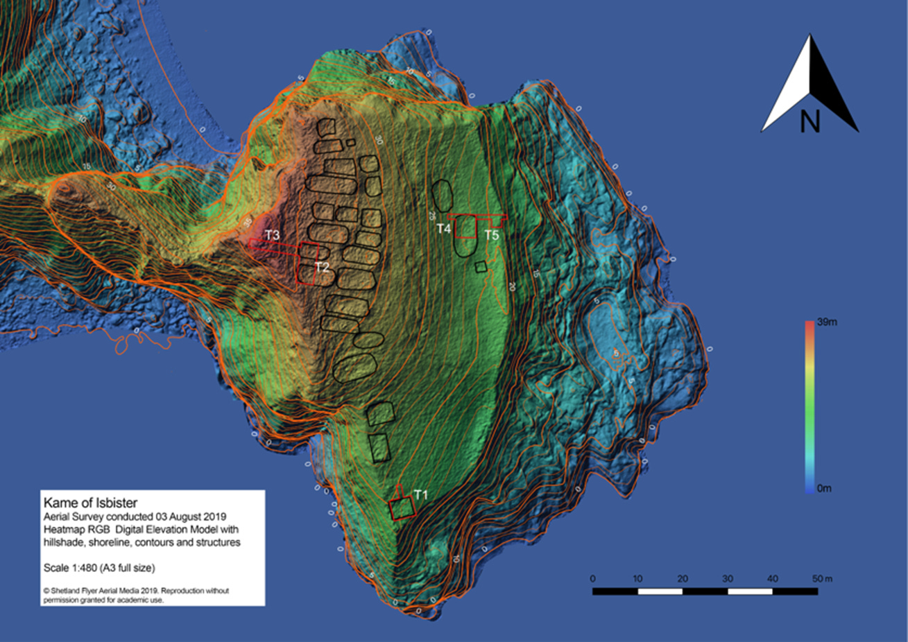
From 2014 onwards, sustained effort to understand the site gathered pace. I used drone photogrammetry to produce a 3D model of the headland. In September 2014, I accessed the site by swimming from a boat and climbing the rocks with colleagues Dr Simon Clarke and Dr Marc Chivers—spending 15 minutes on site exploring the buildings and embankment. A return visit in August 2018 saw an hour spent measuring buildings and assessing whether safe roped access was feasible; it was. Sub-centimetre accurate drone models, created with GPS data in 2019, provided the detailed baseline for the excavation that followed in 2024.
A Scheduled Monument in Trouble
Before discussing what we found in the ground, it is worth being direct about the condition of the site, because it shapes everything about how we think the archaeology should be approached.
Cockburn recorded 23 buildings in 1876. Clarke could only identify 19 in 1970. The drone survey suggests similar numbers to Clarke’s count, meaning at least four buildings Cockburn saw have been lost to the sea. Comparing the 1970 OS plan with the current elevation model makes the scale of change stark: an area of the stack on the southernmost side has been lost entirely, and land east of the landward bank recorded in the 1970s has now gone.
The 2024 season made the situation still clearer. The access ridge had degraded substantially since 2003. Where Hirst’s team in 2003 had a level walk to the foot of the first ascent, we had to descend 2-3m before beginning to climb. Fresh erosion scars were prominent near the most difficult section. The seaward bank or rampart had been removed entirely at the location where we had proposed Trench 5. The landward rampart section is now perched on overhanging bedrock—it cannot always have been in that position—indicating active undercutting from below. Extensive burrowing is now present across the landward rampart. The northern stretches of the rampart have been lost entirely, and the exposed sections show little stone component, suggesting this may always have been primarily an earthen bank.
There is no question that access will continue to deteriorate, and that elements of the monument itself will continue to be lost. This makes further work urgent, while also making it progressively harder to carry out.
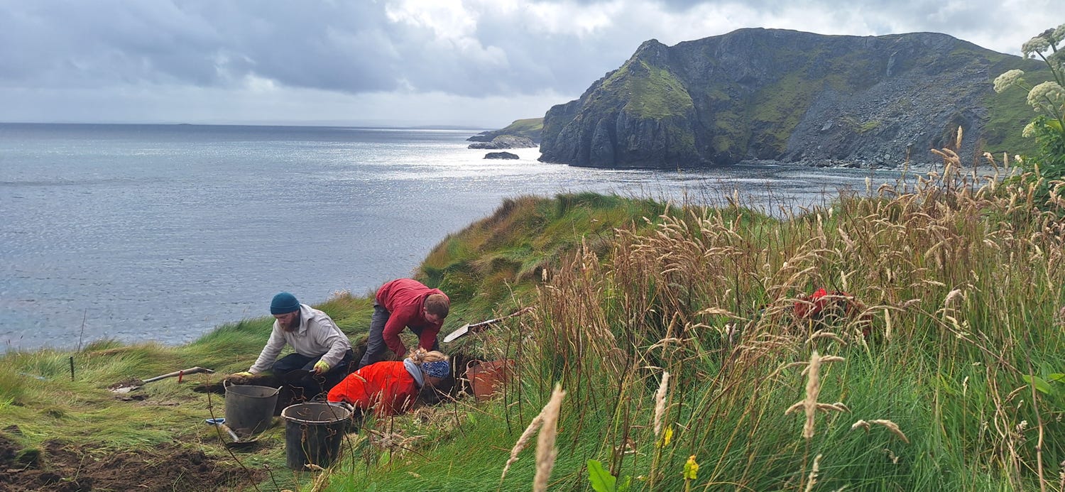
The 2024 Excavations
Scheduled monument consent was obtained to excavate a series of evaluation trenches targeting the buildings, the ramparts, and the spaces between structures. Access constraints significantly limited what was achievable: it took 45 minutes to an hour to get two archaeologists safely onto site on each occasion. Four trenches were opened; Trenches 3 and 5 were not attempted—Trench 3’s location was riddled with otter burrows, and the rampart at Trench 5’s proposed location had been removed by erosion.
Trench 1
Trench 1 (2 x 2 m) targeted one of the eroding structures at the southern end of the stack. Below topsoil (1001) and an overburden of shattered stone (1002, c.0.15m), a very thin deposit of yellow-brown clayey silt (1003) was identified that might represent an ephemeral floor surface. On reflection, this area appears on the 3D model to be an erosion hollow rather than a standing structure; any building that was here has most likely already fallen into the sea.
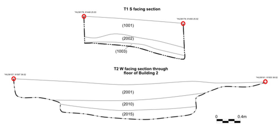
Sections through Trench 1 and floor 2015 in Trench 2.
Trench 2
Trench 2 was the productive heart of the season. L-shaped in plan, it measured approximately 1.8 x 5.5 m across Building 1 and around 3 x 4 m across Building 2, with a passageway (context 2026) of approximately 0.8m between the two structures.
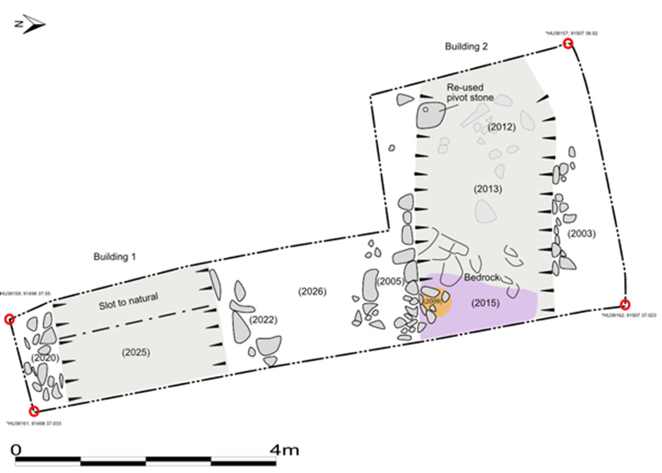
Trench 2 showing floors, walls and other features of Building 1 and 2.
In Building 1, a shallow floor or foundation layer (2025) of mid-greyish brown clayey silt was entirely sterile—no charcoal, no organics—which is in itself telling. Around 40% of the deposit was sampled, the rest left in situ. At the top of the deposit, an iron angle-backed knife (Find 201) was recovered. This is a form well known in both Pictish and Viking secular contexts, a straightforwardly domestic object. The two walls of Building 1 (2020 and 2022) were each built of single-faced local stones revetting an earth or turf core, surviving to around 0.4m.
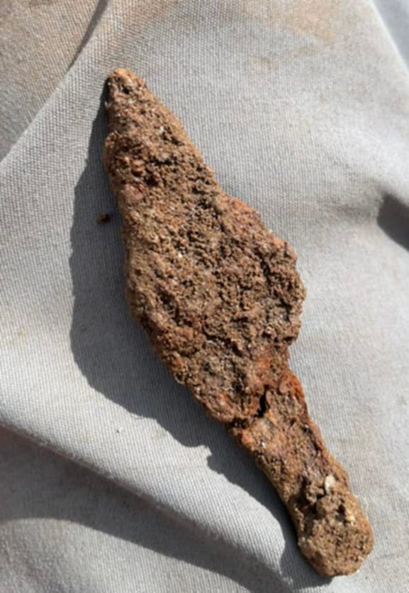
Angle-backed knife from Trench 2 Building 1.
Building 2 offered a more complete sequence. The southern wall (2005) was the best-built element in the trench, surviving to 0.4m in three coursing levels, using local metamorphosed sandstones and mudstones. The northern wall (2003) survived to similar height with up to four courses. Both walls shared an important feature: the upslope c.1.4m of each had no formal stone facing at all, simply cut into the natural soils of the stack. This end of each building was probably a storage area: the basal deposit (2013) was almost entirely sterile, with only a rough paving surface (2012)—including a reused pivot stone—as evidence of any formal floor treatment.
The downslope end told a different story. A floor deposit (2015) of mid-reddish brown clayey silt with occasional charcoal and ash flecks represented a beaten-earth living surface. At its top was a line sinker stone—a perforated pebble used for dorro fishing, specifically for catching saithe in the medium-depth waters of Yell Sound (Chivers 2019). The hearth (2009) abutting the southern wall was compact—about 0.5 x 0.4 m 0.1m deep—filled with dark, charcoal-rich silt containing burnt small twigs and fragments of burnt bone. A bulk sample (S201) was taken from the hearth and a further sample (S202) from the floor deposit for radiocarbon dating and environmental analysis.
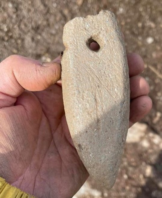
Line sinker from Building 2, Trench 2.
Overlying both buildings’ floors was a stone collapse layer (2010) up to 0.3m deep, with the bulk of material concentrated at the upslope end—consistent with natural deposits pushing out the upper wall courses over time. Above the collapse sat approximately 0.2m of shattered stone (2002) from further degraded wall material, then topsoil.
Trench 4
Trench 4 (m) targeted the isolated building on the east side of the site—the ‘boat-shaped structure’ of the Extreme Archaeology report. Our trench extended from the uphill western side into the interior.

A wall (4005) was identified on the western side, around 0.3m wide and 0.1m high, in two main courses of local stone. Below the stone collapse (4002) inside was a floor or foundation deposit (4003) of occasional flat slabs in a matrix of gravel and yellow-brown clayey silt. A small charcoal concentration (4004, c.0.02m thick) was identified on the floor surface towards the upslope side, and a bulk sample (S402) was collected for dating. Like the other buildings, the interior showed remarkably little accumulated deposit.
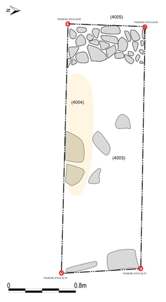
Trench 4 plan.
A New Chronology: Results of the 2024 Dating
The most significant result from the 2024 season is the arrival of four new radiocarbon dates. These provide a much firmer chronological anchor than the single date obtained in 2003, and the results are later than previously expected. Activity at the Kame is now looking squarely like a later 10th- through to early 12th-century phenomenon.
Statistical modeling of these dates, alongside the 2003 sample, suggests a 68% likely start date of 880–990 cal AD and an end date of 1030–1130 AD. This refined chronology places the site not at the beginning of the Viking transition, but firmly within the period of consolidation.
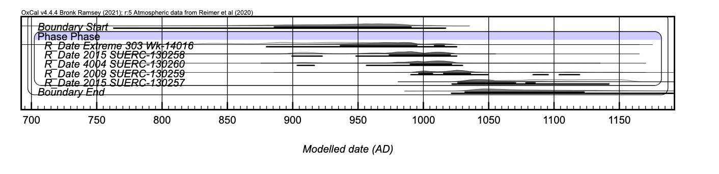
A crucial interpretive detail is that the charcoal from the 2024 season (Building 2 hearth, floor, and Building 4) comes primarily from heather. In the Shetland context, this likely represents the burning of peat. Because peat can be significantly older than its time of use, these dates must be used as a terminus post quem (TPQ) for the individual structures. This reinforces the likelihood that the site’s primary use was in the 11th century or even later, potentially connecting it to the consolidation of the Norse Earldom.
What Does It Mean? The Interpretive Debate
The Case Against a Monastery
The monastic interpretation has never rested on particularly solid ground, and the 2024 results do nothing to support it. Genuine early medieval monastic sites in Scotland and Ireland consistently produce specific markers: carved stone sculpture, cross-slabs, shrine fragments, chapels with characteristic orientations, clochan ‘beehive’ cells, leachta altar stones. The Kame has none of these—not in the 2024 trenches, not in Cockburn’s account, not in the Extreme Archaeology investigation. Monastic sites associated with the papar are typically found on good agricultural land (MacDonald 1977); the Kame is a barren eroding stack.
The new dates further weaken the monastic argument by placing activity in a period long after the peak of the eremitic movement in the north. Furthermore, place-name evidence is instructive. While the name derives from Scots kame (’steep-sided ridge’), likely from Old Norse kambr, while Isbister reflects ON bolstadr (’farm settlement’)—suggesting the original name of the settlement has been lost, significantly, other stack sites in Shetland discussed by Lamb do carry relevant terminology: Burri Stacks, Strandibrough, Sumburgh, and Burgar all derive from Old Norse borg, meaning ‘fort’ (Jennings 2020).
Stronghold, Assembly Site, or Both?
The question of exactly what kind of secular site the Kame represents remains genuinely open. One compelling possibility is that it functioned as an early Norse assembly or thing-site. The building forms are strikingly similar to the seasonal booths (Búðir) documented at the medieval assembly site of Skuldaþingsey in Iceland, where structures range from 5.8 x 4.3 m to 11 x 5.3 m (Vesteinsson et al. 2004)—closely bracketing the Kame’s dimensions. Icelandic assembly booths typically had permanent stone and turf walls but temporary roofs, which aligns with the quickly-built character of the walls and the shallow floor deposits found in 2024. The 11th-century dates now place the site in the heart of the period of increased political organization in the Earldom.
A stronghold interpretation is equally plausible. The Orkneyinga Saga‘s account of the 12th-century chieftain Sveinn Asleifarson and his vigi at Lambaborg in Caithness—a sea-cliff fortress from which he raided—is suggestive of exactly the kind of use the Kame’s topography would have supported. The Kame may have been a high-status center connected to the consolidation of the Earldom, commanding Yell Sound during a period of intense regional power struggles.
The artefacts from 2024 are modest but consistent. The iron angle-backed knife is a domestic tool. The line sinker points to active exploitation of the fisheries. The hearth in Building 2, domestic and compact, implies seasonal or intermittent habitation. The consistently thin, largely sterile floor deposits across all sampled structures is perhaps the most significant overall finding: this is not a site of intensive, long-term occupation. Whether that reflects seasonal assembly use or periodic raiding activity, we cannot yet say with confidence.
What Comes Next
The 2024 season has confirmed both that there is more to find and that the urgency of finding it is real. Further excavation is desirable and, given the erosion situation, increasingly urgent. The better-preserved buildings in the site’s interior should be the priority for future seasons. The rampart areas and erosion margins are now largely unsuitable: too disturbed by burrowing, too undercut, and too dangerous to work safely. There is still much the Kame can tell us about the Norse period in Shetland, but the window for gathering that evidence is narrowing with every storm.
Thanks to Gordon Noble, Charlotta Hillerdal and Elisabeth Niklasson; Department of Archaeology, University of Aberdeen; and Simon Clarke, University of the Highlands and Islands.
References
Ballin Smith, B. 2007. Norwick: Shetland’s First Viking Settlement? In B. Ballin Smith et al. (eds.), West over Sea. Leiden/Boston: Brill, 289-304.
Barrett, J.H. and Slater, A. 2009. New excavations at the Brough of Deerness. Journal of the North Atlantic 2, 81-94.
Chivers, M. 2019. New finds reveal an ancient fishing saga. Moder Dy. Gordon, G. 1878. Notice of ... ruined structures styled Picts houses on the Kame of Isbister. PSAS 12, 202-206.
Hirst, K. et al. 2003. Extreme Archaeology: Kame of Isbister, Shetland Islands. Mentorn TV.
Jennings, A. 2016. Continuity? Christianity and Shetland. In Shetland and the Viking World. Lerwick, 47-53.
Jennings, A. 2020. A potential Viking fort in Shetland: the extraordinary Kame of Isbister. In Viking Encounters. Aarhus: Aarhus University Press, 345-354.
Lamb, R.G. 1973. Coastal settlements of the north. Scottish Archaeological Forum 5, 76-98.
Lamb, R.G. 1980. Iron Age Promontory Forts in the Northern Isles. BAR 79. Oxford.
Palsson, H. and Edwards, P. 1978. Orkneyinga Saga. London: Penguin.
Vesteinsson, O. et al. 2004. A New Assembly Site in Skuldathingsey. In Current Issues in Nordic Archaeology. Reykjavik, 171-177.